I was chatting with my brother about my recent attempts at satellite tracking, and he expressed the opinion that it would be nice to present some of the details about how I actually figure out where satellites are. I’m not sure that my methodology is particularly noteworthy, but here’s what I use:
There are lots of great programs for Windows to do satellite tracking (I’ll try to dig up some links for some and post them later), but I am sworn never to use Microsoft operating systems again, so I needed a different solution. I use a fairly low tech solution, namely the predict software by John A. Magliacane, KD2BD. It’s a open source program that was developed under Linux and released under the GPL. It’s pretty straightforward, so it shouldn’t be hard to port it to any unix-like operating system. There are even fancy front ends which create fancy X11 displays. Me, I mostly use the classic curses version. It’s quick, and I can run it on any of the machines I’m likely to have handy, or can ssh to in a pinch.
All these programs require a set of orbital elements, which are basically a set of numbers that define the orbits of satellites. These numbers are available from a number of sources: I fetch them automatically using a simple cron job on my unix box so they are always up to date. For instance www.celestrak.com/NORAD/elements/amateur.txt always contains the most recent orbital elements for amateur satellites. Similarly, there are links for visually observable satellites, weather satellites, and the Space Shuttle (if up) and the ISS. The format of these files is pretty simple: each satellite is defined by three lines, the first containting the name, and the second and third containing a bunch of numbers that define the orbit. To make predict use these, create a file called predict.tle in your ~/.predict directory that contains up to 24 of these satellites. That’s pretty much it. When you run predict for the first time, it will ask you where on the earth you are (lat, long, and altititude), and then present you with a menu that allows you to do a bunch of interesting stuff, like predict passes for a particular satellite, show details of a single satellite, or the current position of all the satellites. It’s pretty simple really.
For instance: here is the multi satellite tracking display that I get. Most of the satellites are amateur satellites that are worth tracking.
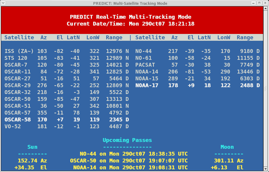
If you look carefully, you’ll see that AO-58 is currently up (it has a positive elevation). If you shift to the single satellite display, you can get more detailed information, that looks like this:
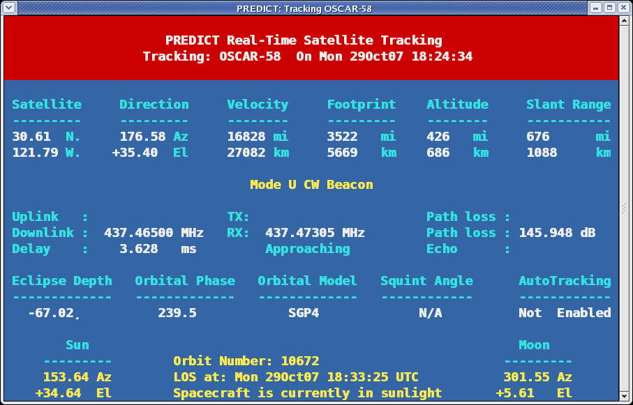
Of particular use to the radio amateur are things like the RX frequency, youll see it is a bit above the nominal downlink frequency. Because it is approaching, the beacon is Doppler shifted up in frequency, and you have to tune high to hear it. You can also see that the distance to the satellite is about 676 miles, and that the path loss to the satellite is about 146db.
This is all useful for interactive use, but you can also get some details about a pass of a satellite using the “P” or predict command. For instance, today’s tracking of the packet satellite NO-44 gives the following:
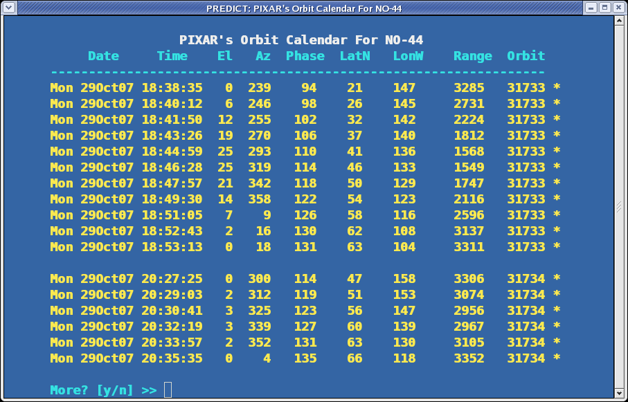
The next pass begins at 18:UTC, and begins at azimuth 239 (south west). It reaches a maximum elevation of 25 degreees about 7 minutes later, at around azimuth 300, and then we get loss of signal at 18:53, almost due north at azimuth zero.
This program has a number of additional capabilities, such as being able to predict the position of the sun, the moon, and visible passes of satellites. If you are looking for something more glorious, you can try installing the gpredict package on your Linux box:

If you are using Windows, there are some great options, the one that seems the nicest that I’ve seen recommended is Orbitron, which has the added advantage of being free (the author just wants you to send him a postcard). Try it out.
[tags]Amateur Radio, Satellite Tracking[/tags]
Pingback: Ghillie Suits » How I track satellites…
Very nice informations