Mostly just the regulars, got W0DXC, which is one of those annoying club addresses with no email contact on QRZ. Sigh, oh well. W0DXZ (thanks Ben, for correcting me). Heard from WA8SME Mark, KG7EZ Chris, W6GMT Brock, WA6DIR Larry and probably a couple of others.
Monthly Archives: January 2008
Trying to record some of VO-52…
Tuning for the Doppler shift on VO-52 is a bit challenging, particularly when you have an antenna in one hand. You all are probably bored with this stuff, but here’s my evening passes recording. It was pretty nice: you can hear WD4FU, the Gainesville, FL station for the University of Florida radio club. It’s the first time I remember hearing a Florida station, and my Maidenhead gridsquare calculator lists its distance at about 3800km. Nice. I am still having difficulty knowing exactly how to adjust the tuning to get natural sounding SSB, but a few more passes, and I bet it will be second nature.
Oh… Did I not tell you what VO-52 was? It’s an Indian amateur radio satellite that carries a linear transponder: it maps a segment of the 70cm spectrum on its uplink to a portion of the 2m spectrum for its downlink. The nice thing is that it can carry several different conversations at once, either in SSB or in CW.
Weird Sound Generator
Here’s a link for Tom: a kit for the Weird Sound Generator. Unlike many of these things, I actually found the variety and quality of sounds produced by this thing to actually be pretty darned interesting. It might be fun to build one of these and work on your own soundtrack for Return to the Forbidden Planet. Check it out:
Weird Sound Generator
Here’s an MP3 of the example sounds you can make with this gadget.
New Radio on AO-51
Well, last night I went and programmed in the various doppler shifted frequencies for AO-51 into the new FT-817, and then this morning worked the morning pass half duplex with Leo, W7JPI and W6GMT. The recording of course doesn’t include my own voice, but the audio quality was really good. You can occasionally hear a beep tone, that’s where I hit the up switch on the mic to move to the next pre-programmed Doppler setting. Very nice.
Another try at LO-19 on some new equipment
Well, I couldn’t stand it anymore. I picked up a new Yaesu FT-817ND to expand my capabilities. It’s a neat little radio, and tunes all the way from 160m up to 70cm, and has SSB, AM and CW capabilities. Neat.
My idea was to try to listen to AO-16: I figured that the Doppler would be easier to handle by hand. I didn’t have much luck though, so I decided to try to write a simple program that interfaced to my Python code to do automatic Doppler correction. Basically, it tunes the radio every couple of seconds according to where it predicts the downlink frequency to be.
Well, it didn’t work that well on the next pass (I’ll try again), but I noted that LO-19 was coming up, and it’s very loud, so I modified the script to track its frequency, and got the following recording:
LO-19’s Morse Telemetry Beacon
If you look or listen carefully, you can hear where the receiver retunes (it makes an annoying little weedle, and you can see the frequency jump in the middle of a dash in several places). But overall, the morse stays pretty darn stable in frequency.
Neat for a few minutes of scripting.
Overlap-Add STFT Processing
Another signal processing link that I think I need to understand:
WA0D on AO-51
The weather here is terrible, and standing outside with an antenna in your hand just isn’t that much fun. But I did manage to handle a few minutes outside. It was rainy, it was cold, but I managed to get WA0D EM12 in Texas before I moved inside (where the noise increased a lot). Not a very pleasant pass to listen to. I think I’ll skip the normal recording.
Volksat
I keep wondering if the whole KISS principle (a personal favorite of mine) might be sensible to apply more thoroughly. Diane, VA3DB pointed me at a satellite design I hadn’t seen before: a picosat that would carry aerogel ultracaps as well as traditional nicads. It was dubbed Volksat. I think there are lots of sensible and good ideas contained here.
Script to predict satellite passes…
Well, my plan13 library has been joined with a library that decodes grid squares and the like, and another which downloads orbital elements and stores them in an sqlite3 database. The combination of all these allows you to write simple programs like the one I illustrate below, which gives predictions of the named satellites from any grid (defaulting of course to my own gridsquare). Witness:
[chessboard] % ./nextpass -v ARISS AO-27 SO-50 AO-51
ARISS [+] will be visible from CM87 in 0:54:30 at 02:51:30
        AOS: 02:51:29  -0.0°  163.2°
        MAX: 02:54:29  +4.4°  124.1°
        LOS: 02:57:27  +0.0°   86.0°
AO-27 [+] will be visible from CM87 in 7:53:15 at 09:50:15
        AOS: 09:50:11  -0.0°   46.9°
        MAX: 09:55:01  +6.2°   87.2°
        LOS: 09:59:45  +0.0°  127.0°
SO-50 [+] will be visible from CM87 in 6:16:45 at 08:13:45
        AOS: 08:13:44  -0.0°  159.7°
        MAX: 08:19:09 +12.3°  106.6°
        LOS: 08:24:47  +0.0°   53.6°
AO-51 [+] will be visible from CM87 in 0:42:30 at 02:39:30
        AOS: 02:39:23  -0.0°  146.5°
        MAX: 02:46:48 +41.0°   69.8°
        LOS: 02:54:14  +0.0°  356.3°
Gravner-Griffeath Snowfakes
I still read stuff that isn’t radio relate. Some of it I’m sure most of you wonder “what kind of a nut are you, that you are interested in that?” Oh well. Here’s more reinforcement for the idea that I find crazy stuff interesting: a bunch of articles on models for snowflake formation:
Awesome High Altitude Balloon Flight
Well, the price of launching a satellite for real is still way too high to be even an insane possibility, but there are some fun things that a space minded individual or club can do: notably, high altitude balloon launches. Witness this one, which came across the Make Blog today. It includes some pretty nifty high altitude video from the edge of space.
Flight 2 – High ALtitude Object
MVI_0466 from natrium42 on Vimeo.
Globe trotting, er… plotting…
My old program for drawing globes made some nice postscript output, but in reexamining the source code, I can only imagine that I was doped up on cough medicine while working on it. I started a bit on a revamp of it, starting by purloining the matrix and vector library that I used in my old raytracer and swiping the outline data from xearth. A couple of hours of TV watching and coding later, and I have the basics fleshed out:

I’m not 100% satisfied with it, since the coordinate system that it currently uses is the default one that xearth uses, and which is not the same as used by the internals of the plan13 code that I will eventually interface to it. It’s not
especially critical, but I think it makes a less clear presentation. I’ll tighten it up later.
It also doesn’t do any filling of the continent outlines, which I’m not really sure is a flaw: my goal is not to present a photorealistic view of the earth, but rather to show a clear schematic of the path of satellites as they orbit the earth. Still, I’ll give it some thought.
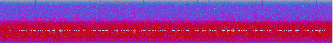
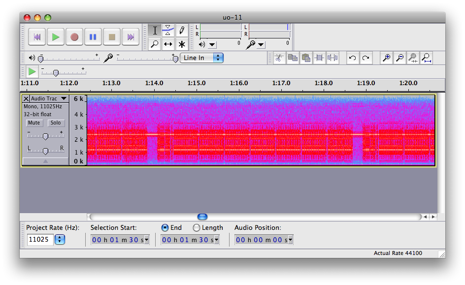
UO-11 also wakes up from its nap…
Another old time satellite might be waking up from its sleep as it comes out of a period of eclipses. Joanne Maenpaa mentioned that UO-11’s telemetry beacon had been heard on 145.825, so I decided to try to give it a listen on its pass to the east. Despite the fact that it was fairly low, I heard the 1200 baud AFSK telemetry quite clearly. I don’t have the ability to decode it (couldn’t find any Mac programs that would), but I recorded a couple of minutes of it using Audacity on my mac anyway. Because someone might be able to decode it from this data, here’s the compressed .wav file:
UO-11 Telemetry, 2008-01-23 around 04:27 UTC
Here’s a screen dump of Audacity, showing the 1200 and 2400 Hz carriers that make up the AFSK signal.
Addendum: Douglas Quagliana, KA2UPW did what I hoped someone would: ran my recording successfully through his own UO-11 decoder. From the email he sent me:
Hi Mark,
 Thanks for posting the recording!

 I downloaded your recording and ran it through
my DSP soundcard UO-11 demodulator. Most of the
data in your recording looks like this, although
other sections are quite noisy.

UOSAT-2           0711024074656
000000010001020002030003040004050005060006070007080008090009
100001110000120003130002140005150004160007170006180009190008
20000221000322000023000124000625000726000427000528000A29000B
30000331000232000133000034000735000636000537000438000B39000A
40000441000542000643000744000045000146000247000348000C49000D
50000551000452000753000654000155000056000357000258000D59000C
60800E615FC1620004633305644402651E0C662AC467000168000E69000F

All of the columns of zeros are telemetry channels that have
failed. This agrees with what Clive has previously reported.


Earlier Clive reported:
>The current status of the satellite, is that all the analogue
>telemetry channels, 0 to 59 are zero, ie they have failed.
>The status channels 60 to 67 are still working. The real
>time clock is showing a large accumulated error [...]

Last month the clock was about 74 days slow, but it is now
about 81 days off.

In the past UO-11 also used to send stored ASCII bulletins
as well, but I think that capability of the satellite ended
when the spacecraft computer turned off. Anyone know
for sure?
Thanks alot Douglas for the decode.
AO-16 lives, in a very strange way…
This just came across the amsat-bb mailing list:
Since AO-16 was recovered approximately 6 months ago, the command team has
attempted to reload the satellite software almost a dozen times without
success. Subsequently a series of memory tests were performed which points
towards a hardware failure which prevents restarting the spacecraft software
successfully. This team included Bruce Rahn WB9ANQ and Jim White WD0E
advising Mark Hammond N8MH as the primary groundstation. Mark put in many
early hours during the multiple reloads and test sessions, with Bruce, Jim,
and others advising. Thank you to all involved for your hard work.

After the conclusion that the spacecraft computer system was damaged and as
discussions about decommissioning were taking place, Jim recalled a series
of low level commands included in the spacecraft design by Tom Clark, K3IO
during construction. One of these commands allows an uplink receiver to be
directly tied to a downlink transmitter. The twist is that the uplink is
regular FM but the downlink via the BPSK transmitter is DSB (Double
Sideband). Mark placed the satellite in this mode early this week and some
testing was undertaken. The satellite hears VERY well, and the reduced
bandwidth by using either USB or LSB on the groundstation receiver allows
for a very robust downlink. Tuning the downlink is just like on a linear
transponder, meaning it is tight and with fast Doppler. Uplink tuning is not
required, just as with the FM mode V/U satellites. QSOs were made between
N8MH, WD4ASW, KO4MA, K5QXJ, and WA6FWF. My personal observations include
being able to access and hear the satellite within one degree of the
horizon, much lower than any other current bird for my QTH. This should be
an easy satellite with omni antennas and a 70cm preamp.

With that explanation, I'm happy to open the satellite to general use on
voice for a test period. Please submit reports either to the -bb or to
ao16@amsat.org . The uplink is 145.920 FM, and the downlink is 437.026 SSB
± Doppler shift. Please restrict your uplink power to a reasonable level,
and do not transmit without being able to hear the downlink. All the general
single-channel guidelines apply. Enjoy this bird's new life!

73, Drew KO4MA
AMSAT-NA VP Operations
Whacky! I don’t have any UHF SSB equipment, so it really doesn’t help me much, but I can imagine that using a cheap 2m handheld for the uplink, and either a TH-F6A or more capable transciever for the downlink would be possible. Neat! I’ll have to give this a try sometime.
Evening passes for AO-51
Couldn’t work the bird at all, it was a low 20 degree pass, and I simply can’t get in when the satellite is crowded like this. Still heard many stations, including N2BX from FN20. I tried to cut in, but I simply got doubled. It would have been a nice DX to West Orange, NJ.
CM87 -> FN20: bearing 70.2° distance: 4139.9 km
Eastern pass of AO-51, I didn’t get in at all. Skip the first minute or two: lots of QRM from something that appears to be active when its cold out.
For the western pass, I got K6RJ Rick DM13 handheld, N6PAA Ron from CM98, some random DTMF codes, WD8PFS from DM12, W5OK came through, I originally said WW5OK, and he never came back (it’s hard to remember what you are saying when operating handheld). I was juggling the Doppler by that time too. Got KF6FNT CM98 also operating portable. Got KE7NLQ DN85, and realized I was off on the Doppler again, but then lost the satellite behind the hills to the north (they fade really quick because of the 25+ degree horizon). That was it for the day.