Daily Archives: 1/20/2008

Evening Western Pass for AO-51…

Got a QSO with KL7XJ, from BP40 near Anchorage Alaska. Not bad, according to my calculator, that’s about 3250km. Also got regulars VA7VW, and heard KI6FYM calling CQ, but he apparently didn’t hear anyone responding. I’m not sure what his problem was: I don’t think it was just simply being off on Doppler. I think he must have been on a completely different downlink frequency.

That’s why having a full duplex rig is so useful: literally, if you can’t hear yourself, nobody else probably can either.

Western Pass of AO-51, Jan 20, 2008

Decoding LO-19 Telemetry…

I heard that the telemetry signal from LO-19 was quite strong, and could be easily picked up with even the simplest equipment. It’s sent as 12wpm morse on 437.125 Mhz or so. I don’t really have any equipment that does Morse reception on that frequency, but I figured that I might hear it anyway.

The beacon as received from my FM HT.

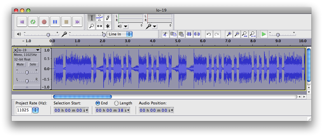
As you can hear, it is audible (very clearly) as decreases in the background noise (precisely what you’d expect). The telemetry consists of “E LUSAT HI HI”, followed by a 2 digit version stamp, and then 8 three digit groups. I’m pretty rusty at Morse, but since I had it recorded, I could just read it directly off the spectrum display in Audacity. Here’s how I read it.

E LUSAT HI HI AO AVA ABV TDT ANV TBE ANA AVU AE6
              	 131 173 080 193 075 191 132 156

		0 = T = -	5 = E = .
		1 = A = .-	6 = 6 = -....
		2 = U = ..-	7 = B = -...
		3 = V = ...-	8 = D = -..
		    4 = ....-	9 = N = -.


-----------------------------------------------------------
Channel			Formula			Value
-----------------------------------------------------------
CH 1: +5 volts 		(639/x)			+4.88 volts
CH 2: +10 volts		(0.064*x)		+11.0 volts
CH 3: Cw xmtr. temp.	0.353*(134.7-x)		19.3 deg. C
CH 4: Output power TX	((10.9+x)^2)/40.1	1027 mw
CH 5: Box temp #4.	0.356*(136-x)		21.7 deg. C
CH 6: +10 v current	0.7*x			134 ma
CH 7: +Z voltage panel	0.15*x			19.8 volts
CH 8: +8.5 voltage	0.056*x			+8.74 volts
-----------------------------------------------------------

Pretty nifty.

Addendum: Robert, NH7WN (whom I’ve chatted with on the birds before, giving me the awesome BL11 gridsquare, which is Hawaii) sent me an awesome picture of a cute little QFH antenna and a screen dump of Sound Forge, which is how he read off the LUSAT telemetry. I did it precisely that way too, but I used Audacity. Here’s the waveform display, and if you know Morse, you will be able to read “E LUSAT HI HI” by interpreting the quieter regions as dots and dashes.


Dots and dashes…

All the alligators come out on SO-50…

Alligators have big mouths, but little ears. On a satellite, an alligator is someone who sends a loud signal without listening, effectively trashing someone elses communication. On this SO-50 pass, I was having some difficulty getting in because people are obviously hitting transmit without listening for each other. I tried to get the downlink a couple of times, but only managed to get it once. Somebody out there did here me, a WA6 station, but I didn’t manage to get the callsign. I heard regulars VA7VW and W0SAT.

You probably don’t want to listen to this crappy audio, but here it is anyway.

Alligators on SO-50, Jan 20, 2008

Addendum: Amidst all the bedlam, i heard the word “Toronto”, and in relistening, heard the callsign VE3OSC, which is apparently the callsign for the Ontario Science Center in Toronto. According to my geocoding website and my gridsquare calculator, that’s just about 3700km away, which is just a tiny bit further than my previous longest contact, to NH7WN in Hawaii. Neat!

CM87 -> BL11: bearing 251.0° distance: 3726.1 km
CM87 -> FN03: bearing  65.8° distance: 3762.9 km

Addendum2: On the second, western SO-50 pass, I caught VA7VW again, much better, although with the typical strong fading I seem to get on SO-50. He apparently was irritated enough by VE3OSC’s “all talk, no listen” operation that he called them up.

Listen to his comments at the beginning of the followup pass…
NOAA-17 a day later…

Yesterday I posted an image that I had captured from the NOAA-17 weather satellite on a pass over the bay area in the mid morning. Today, I did the same thing. Whereas yesterday the weather was reasonably clear, today, it was a bit cloudier and colder, and you can see the difference a day makes in the weather.

For these passes to the east, I really only get noisefree images for about six minutes: mostly when the satellite is above roughly 20 degrees. I need a higher antenna, and a better receiver and/or preamp to do much better. Still, I’m pretty pleased. Even with the odd sparks of noise, the image are kind of cool.

Yesterday Today
Jan 19th, 2008, NOAA-17 Jan 20th, 2008, NOAA-17

Addendum: I tried to create an animation of the two days by aligning them using GIMP. It’s not the greatest tool for this, but it sort of works. There is some kind of wavy distortion, because I suspect that the way that the APT transmission works doesn’t exactly preserve angles and the like. But you might like it.


An animation of both frames…

Click on the image above to see both frames alternating. Warning: it might nauseate you after a while of staring at it.