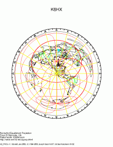
I don’t have the right antennas or the best setup for decoding, but I can still occasionally hear some of the more local NAVTEX stations, and using MultiPSK (capable, but man, is that one program in need of a makeover) I managed to decode some of the alerts. Without further ado:
PACIFIC COAST HIGHWAY BRIDGE NAVIGATIONAL LIGHTS REPORTED
INOPERATIONAL DUE TO A POWER OUTAGE.

NNNN
BRK
ZCZC QA04
CCGD11 BNM D11 0110-10
1. CALIFORNIA - GULF OF SANTA CATALINA
OCEANSIDE DANGER BUOY (LLNR 2317) IS MISSING.

NNNN
BRK
ZCZC QE42
DGPS BNM 133-10
AUSTIN, NV DGPS BROADCAST SITE IS UNUSABLE AS OF 071145Z FEB
10 UNTIL
FURTHER NOTICE.

NNNN
BRK
ZCZC QA64
CCGD11 BNM D11 0113-10
1. CA-SAN CLEMENTE ISLAND
HAZARDOUS OPERATIONS WILL TAKE PLACE AT THE FOLLOWING TIMES:

 090800T-091200T FEB 10
 101700T-102130T FEB 10
IN AN AREA BOUND BY THE FOLLOWING COORDINATES:
 32-55-00N  118-25-00W
 32-55-00N  118-15-00W
 32-45-00N  118-15-00W
 32-45-00N  118-25-00W
 TO POINT OF ORIGIN.
MARINERS ARE ADVISED TO STAY CLEAR OF THIS AREA.
2. CANCEL BROADCAST AT TIME//110530Z FEB 10//

NNNN
BRK
ZCZC QA19
CCGD$1 BNM D11 0123-10
1. CALIFORNIA - NEWPORT BAY
NEWPORT BAY CHANNEL LIGHT 11 (LLNR 2470) HAS BEEN
REPORTRD EXTINGUISHED.

NNNN
BRK
ZCZC QA90
CCGD11 BNM D11 0115-10
1. CA-SAN CLEMENTE ISLAND
HAZARDOUS OPERATIONS WILL TAKE PLACE AT THE FOLLOWING TIMES:

 100700T-101700T FEB 10
 110700T-111700T FEB 10
 120700T-120700T FEB 10
IN AN AREA BOUND BY THE FOLLOWING COOODINATES:
 32-55-00N  118-25-0-W
 32-5--00N  118-15-0-W
 32-40-00N  118-15-00W__
  2-20-_0PU  118-35-00W W
_  2-25-00N 111-35300WI_
 TOTP_INTIOFOF_ IRINJM
MUMPNPNS ARZ AJBJSED TO A GAT_
