I recall burning three or four weeks of a sabbatical getting Saccade.com on the air with Wordpress. So much tweaking…
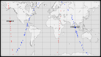
Earlier, I blogged about the collision between Iridium 33 and the defunct COSMOS 2251 satellite. Today, I noticed that Celestrak had orbital elements for 134 fragments resulting from the collision. I was curious what the resulting pattern would look like, so I wrote a bit of code to suck them all in and plot them on a map. Here’s what I got for a particular moment around noon local time.
The labeled points are the tracked location of the main body of the satellite. There are orbital elements for 48 additional fragments of Iridium, and 84 additional fragments of COSMOS. The main body of Iridium 33 was at 785km altitude, while Cosmos is down around 771km. Debris is scattered over quite a wide variety of altitudes, from a low of 284km to a high of 1158km.
Comments
Comment from Karl-Martin Skontorp
Time 2/22/2009 at 2:50 pm
How about showing the altitude with different shades of blue/red?
Comment from Mark VandeWettering
Time 2/22/2009 at 3:02 pm
Sadly David, I don’t think I can reliably do it with the software that I have. I do have the orbital elements from before, but my code is the most simple orbital model, and is probably only good for a few days around the date specified in the orbital elements. A more sophisticated code would be necessary for that.

Comment from D. Eppstein
Time 2/22/2009 at 2:43 pm
I’m curious how well the red and blue tracks line up with where the orbits would have been without the collision. I guess I have a mental model in which the two satellites have something resembling an elastic collision, and end up on two new orbits, but then the shock shatters them into lots of pieces which spread out along the new orbits. Or are they still in basically the orbits they were on before, but in lots of little pieces?