Monthly Archives: January 2008

Evening Western Pass for AO-51…

Got a QSO with KL7XJ, from BP40 near Anchorage Alaska. Not bad, according to my calculator, that’s about 3250km. Also got regulars VA7VW, and heard KI6FYM calling CQ, but he apparently didn’t hear anyone responding. I’m not sure what his problem was: I don’t think it was just simply being off on Doppler. I think he must have been on a completely different downlink frequency.

That’s why having a full duplex rig is so useful: literally, if you can’t hear yourself, nobody else probably can either.

Western Pass of AO-51, Jan 20, 2008

Decoding LO-19 Telemetry…

I heard that the telemetry signal from LO-19 was quite strong, and could be easily picked up with even the simplest equipment. It’s sent as 12wpm morse on 437.125 Mhz or so. I don’t really have any equipment that does Morse reception on that frequency, but I figured that I might hear it anyway.

The beacon as received from my FM HT.

As you can hear, it is audible (very clearly) as decreases in the background noise (precisely what you’d expect). The telemetry consists of “E LUSAT HI HI”, followed by a 2 digit version stamp, and then 8 three digit groups. I’m pretty rusty at Morse, but since I had it recorded, I could just read it directly off the spectrum display in Audacity. Here’s how I read it.

E LUSAT HI HI AO AVA ABV TDT ANV TBE ANA AVU AE6
              	 131 173 080 193 075 191 132 156

		0 = T = -	5 = E = .
		1 = A = .-	6 = 6 = -....
		2 = U = ..-	7 = B = -...
		3 = V = ...-	8 = D = -..
		    4 = ....-	9 = N = -.


-----------------------------------------------------------
Channel			Formula			Value
-----------------------------------------------------------
CH 1: +5 volts 		(639/x)			+4.88 volts
CH 2: +10 volts		(0.064*x)		+11.0 volts
CH 3: Cw xmtr. temp.	0.353*(134.7-x)		19.3 deg. C
CH 4: Output power TX	((10.9+x)^2)/40.1	1027 mw
CH 5: Box temp #4.	0.356*(136-x)		21.7 deg. C
CH 6: +10 v current	0.7*x			134 ma
CH 7: +Z voltage panel	0.15*x			19.8 volts
CH 8: +8.5 voltage	0.056*x			+8.74 volts
-----------------------------------------------------------

Pretty nifty.

Addendum: Robert, NH7WN (whom I’ve chatted with on the birds before, giving me the awesome BL11 gridsquare, which is Hawaii) sent me an awesome picture of a cute little QFH antenna and a screen dump of Sound Forge, which is how he read off the LUSAT telemetry. I did it precisely that way too, but I used Audacity. Here’s the waveform display, and if you know Morse, you will be able to read “E LUSAT HI HI” by interpreting the quieter regions as dots and dashes.


Dots and dashes…

All the alligators come out on SO-50…

Alligators have big mouths, but little ears. On a satellite, an alligator is someone who sends a loud signal without listening, effectively trashing someone elses communication. On this SO-50 pass, I was having some difficulty getting in because people are obviously hitting transmit without listening for each other. I tried to get the downlink a couple of times, but only managed to get it once. Somebody out there did here me, a WA6 station, but I didn’t manage to get the callsign. I heard regulars VA7VW and W0SAT.

You probably don’t want to listen to this crappy audio, but here it is anyway.

Alligators on SO-50, Jan 20, 2008

Addendum: Amidst all the bedlam, i heard the word “Toronto”, and in relistening, heard the callsign VE3OSC, which is apparently the callsign for the Ontario Science Center in Toronto. According to my geocoding website and my gridsquare calculator, that’s just about 3700km away, which is just a tiny bit further than my previous longest contact, to NH7WN in Hawaii. Neat!

CM87 -> BL11: bearing 251.0° distance: 3726.1 km
CM87 -> FN03: bearing  65.8° distance: 3762.9 km

Addendum2: On the second, western SO-50 pass, I caught VA7VW again, much better, although with the typical strong fading I seem to get on SO-50. He apparently was irritated enough by VE3OSC’s “all talk, no listen” operation that he called them up.

Listen to his comments at the beginning of the followup pass…

NOAA-17 a day later…

Yesterday I posted an image that I had captured from the NOAA-17 weather satellite on a pass over the bay area in the mid morning. Today, I did the same thing. Whereas yesterday the weather was reasonably clear, today, it was a bit cloudier and colder, and you can see the difference a day makes in the weather.

For these passes to the east, I really only get noisefree images for about six minutes: mostly when the satellite is above roughly 20 degrees. I need a higher antenna, and a better receiver and/or preamp to do much better. Still, I’m pretty pleased. Even with the odd sparks of noise, the image are kind of cool.

Yesterday Today
Jan 19th, 2008, NOAA-17 Jan 20th, 2008, NOAA-17

Addendum: I tried to create an animation of the two days by aligning them using GIMP. It’s not the greatest tool for this, but it sort of works. There is some kind of wavy distortion, because I suspect that the way that the APT transmission works doesn’t exactly preserve angles and the like. But you might like it.


An animation of both frames…

Click on the image above to see both frames alternating. Warning: it might nauseate you after a while of staring at it.

Plan13 code nearing alpha test…

My Python port of the Plan13 algorithm is pretty much working now. I wrote a simple script to find the next pass of NOAA-17, and here is the result for finding the next pass. It outputs the time and date (in UTC), the elevation, azimuth, latitude and longitude of the point directly under the satellite, the range to the satellite, and the Doppler corrected downlink frequency.

It seems to work pretty well.

==============================================================
================ UPCOMING PASSES FOR NOAA-17 =================
==============================================================
2008/01/20 03:55:00  +1.9 102.8 28.4N  93.3W 3141km 137.622Mhz
2008/01/20 03:56:00  +4.4  96.1 31.9N  94.3W 2890km 137.622Mhz
2008/01/20 03:57:00  +6.8  88.2 35.4N  95.3W 2679km 137.621Mhz
2008/01/20 03:58:00  +8.7  79.0 38.8N  96.4W 2520km 137.621Mhz
2008/01/20 03:59:00 +10.0  68.7 42.3N  97.6W 2422km 137.620Mhz
2008/01/20 04:00:00 +10.4  57.8 45.8N  98.8W 2396km 137.620Mhz
2008/01/20 04:01:00  +9.8  47.0 49.3N 100.2W 2442km 137.619Mhz
2008/01/20 04:02:00  +8.4  37.0 52.7N 101.8W 2556km 137.619Mhz
2008/01/20 04:03:00  +6.3  28.1 56.2N 103.6W 2731km 137.618Mhz
2008/01/20 04:04:00  +3.9  20.5 59.6N 105.8W 2955km 137.618Mhz
2008/01/20 04:05:00  +1.3  14.2 62.9N 108.3W 3216km 137.618Mhz
--------------------------------------------------------------

Addendum: I ran my script to find the next pass for AO-27, and wow, it turns out that it passes almost directly over my position. I changed the pass predictor to produce lines every 15 seconds.

==============================================================
================ UPCOMING PASSES FOR OSCAR-27 ================
==============================================================
2008/01/19 22:43:15  +0.8 165.2 12.2N 115.6W 3173km 436.807Mhz
2008/01/19 22:43:30  +1.8 165.2 13.1N 115.8W 3073km 436.807Mhz
2008/01/19 22:43:45  +2.8 165.2 14.0N 116.0W 2972km 436.807Mhz
2008/01/19 22:44:00  +3.8 165.2 14.8N 116.2W 2872km 436.807Mhz
2008/01/19 22:44:15  +4.9 165.3 15.7N 116.4W 2771km 436.807Mhz
2008/01/19 22:44:30  +6.0 165.3 16.6N 116.6W 2671km 436.807Mhz
2008/01/19 22:44:45  +7.1 165.3 17.5N 116.8W 2571km 436.807Mhz
2008/01/19 22:45:00  +8.4 165.3 18.4N 117.0W 2472km 436.807Mhz
2008/01/19 22:45:15  +9.7 165.3 19.3N 117.2W 2372km 436.807Mhz
2008/01/19 22:45:30 +11.0 165.3 20.1N 117.4W 2273km 436.807Mhz
2008/01/19 22:45:45 +12.5 165.4 21.0N 117.6W 2175km 436.807Mhz
2008/01/19 22:46:00 +14.0 165.4 21.9N 117.9W 2077km 436.806Mhz
2008/01/19 22:46:15 +15.6 165.4 22.8N 118.1W 1980km 436.806Mhz
2008/01/19 22:46:30 +17.4 165.4 23.7N 118.3W 1884km 436.806Mhz
2008/01/19 22:46:45 +19.3 165.4 24.6N 118.5W 1788km 436.806Mhz
2008/01/19 22:47:00 +21.4 165.4 25.4N 118.7W 1694km 436.806Mhz
2008/01/19 22:47:15 +23.6 165.4 26.3N 119.0W 1601km 436.806Mhz
2008/01/19 22:47:30 +26.1 165.4 27.2N 119.2W 1510km 436.806Mhz
2008/01/19 22:47:45 +28.8 165.4 28.1N 119.4W 1421km 436.806Mhz
2008/01/19 22:48:00 +31.8 165.4 29.0N 119.6W 1335km 436.805Mhz
2008/01/19 22:48:15 +35.2 165.4 29.8N 119.9W 1251km 436.805Mhz
2008/01/19 22:48:30 +39.0 165.3 30.7N 120.1W 1171km 436.805Mhz
2008/01/19 22:48:45 +43.3 165.3 31.6N 120.3W 1095km 436.804Mhz
2008/01/19 22:49:00 +48.1 165.2 32.5N 120.6W 1025km 436.804Mhz
2008/01/19 22:49:15 +53.5 165.1 33.4N 120.8W  962km 436.803Mhz
2008/01/19 22:49:30 +59.5 164.9 34.2N 121.1W  907km 436.802Mhz
2008/01/19 22:49:45 +66.3 164.5 35.1N 121.3W  861km 436.801Mhz
2008/01/19 22:50:00 +73.6 163.7 36.0N 121.6W  827km 436.800Mhz
2008/01/19 22:50:15 +81.4 161.5 36.9N 121.9W  806km 436.798Mhz
2008/01/19 22:50:30 +89.1 113.7 37.8N 122.1W  798km 436.797Mhz
2008/01/19 22:50:45 +82.4 351.7 38.6N 122.4W  805km 436.796Mhz
2008/01/19 22:51:00 +74.6 348.9 39.5N 122.7W  825km 436.794Mhz
2008/01/19 22:51:15 +67.3 348.1 40.4N 123.0W  858km 436.793Mhz
2008/01/19 22:51:30 +60.5 347.7 41.3N 123.3W  903km 436.792Mhz
2008/01/19 22:51:45 +54.4 347.5 42.1N 123.6W  957km 436.791Mhz
2008/01/19 22:52:00 +48.9 347.3 43.0N 123.9W 1020km 436.791Mhz
2008/01/19 22:52:15 +44.1 347.3 43.9N 124.2W 1089km 436.790Mhz
2008/01/19 22:52:30 +39.8 347.2 44.8N 124.5W 1164km 436.789Mhz
2008/01/19 22:52:45 +36.0 347.2 45.6N 124.8W 1244km 436.789Mhz
2008/01/19 22:53:00 +32.6 347.2 46.5N 125.1W 1327km 436.789Mhz
2008/01/19 22:53:15 +29.5 347.2 47.4N 125.5W 1414km 436.788Mhz
2008/01/19 22:53:30 +26.8 347.2 48.3N 125.8W 1502km 436.788Mhz
2008/01/19 22:53:45 +24.3 347.2 49.1N 126.2W 1593km 436.788Mhz
2008/01/19 22:54:00 +22.0 347.2 50.0N 126.6W 1686km 436.788Mhz
2008/01/19 22:54:15 +19.9 347.2 50.9N 126.9W 1780km 436.788Mhz
2008/01/19 22:54:30 +18.0 347.2 51.7N 127.3W 1875km 436.788Mhz
2008/01/19 22:54:45 +16.2 347.3 52.6N 127.8W 1971km 436.788Mhz
2008/01/19 22:55:00 +14.6 347.3 53.5N 128.2W 2068km 436.788Mhz
2008/01/19 22:55:15 +13.0 347.3 54.3N 128.6W 2166km 436.787Mhz
2008/01/19 22:55:30 +11.6 347.4 55.2N 129.1W 2264km 436.787Mhz
2008/01/19 22:55:45 +10.2 347.4 56.1N 129.5W 2362km 436.787Mhz
2008/01/19 22:56:00  +8.9 347.4 56.9N 130.0W 2461km 436.787Mhz
2008/01/19 22:56:15  +7.7 347.5 57.8N 130.5W 2561km 436.787Mhz
2008/01/19 22:56:30  +6.5 347.5 58.7N 131.1W 2661km 436.787Mhz
2008/01/19 22:56:45  +5.4 347.6 59.5N 131.6W 2760km 436.787Mhz
2008/01/19 22:57:00  +4.4 347.6 60.4N 132.2W 2860km 436.787Mhz
2008/01/19 22:57:15  +3.3 347.6 61.2N 132.8W 2961km 436.787Mhz
2008/01/19 22:57:30  +2.3 347.7 62.1N 133.4W 3061km 436.787Mhz
2008/01/19 22:57:45  +1.4 347.7 62.9N 134.1W 3161km 436.787Mhz
2008/01/19 22:58:00  +0.5 347.8 63.8N 134.8W 3262km 436.787Mhz
--------------------------------------------------------------

Another weather satellite pass…

Jan 19, 2008, NOAA-17Another pass of NOAA-17 this morning. A pretty nice one too, lots of good detail. Not the most noise-free image though: not sure what the regularly timed, strong interference was that comes in at the beginning, but it too seems to be synchronized at the 1hz rate, and may even be tracking the same Doppler. Another satellite? Not sure.

Lawrence Lessig @ Pixar

Stanford law professor and copyright champion Lawrence Lessig came for a lunchtime lecture here at Pixar. I’ve been interested in copyright law and intellectual property rights for quite some time, and Lessig’s thoughtful writing and championing of the Creative Commons has had a significant effect in helping me formulate what I think is a nuanced and reasonable understanding of the issues. Since I have followed much of his writings and his blog, I didn’t find a lot that was significantly new in his presentation. He did take the opportunity to offer a challenge to Pixar and our mouse-eared overlords to take a leadership role in trying to transition into a more sensible culture were “read-write” access to creative works are more sensibly understood.

It’s a pity that his entire time was spent talking about copyright though: I’m now more interested in his new windmill to tilt at.

UVM CricketSat Program

I’ve been toying with the idea of doing a balloon launch, perhaps carrying a full GPS and radio transmitter payload, but I think it would behoove me to get some experience attempting to find payloads that cost only a few bucks before risking hundreds of dollars. This would appear to be the answer: the Cricketsat.

UVM CricketSat Program

These are little transmitters that are kind of like your key fob or whatever. They output a weak signal, but are capable of relaying some basic telemetry back via simple modulation. They cost about $10, and can be carried by a small balloon. Very neat.

Maidenhead Gridsquares

If you’ve listened to some of my satellite audio, you’ll notice that in addition to the callsigns, people are exchanging things that sound like “Delta Mike 41” or “Charlie Mike 87”. These are Maidenhead gridsquares: a system of rapidly transmitting your rough location. The kind most commonly heard are the ones that are 4 characters long (two alpha, followed by two digits), but it’s also not uncommon to have them be length six (two uppercase alpha, two digits, two lower case). Converting back and forth between grids and latitude and longitude is fairly simple, there are existing programs like geoid and wwl that can do it. But I decided to code up a Python library to do it. As a simple test, it takes two grid descriptors, and determines the bearing and the distance between both points. For instance, when I run python maidensquare.py CM87 BL11, I get the following:

CM87 -> BL11: bearing 251.0° distance: 2315.3 miles
BL11 -> CM87: bearing  54.0° distance: 2315.3 miles

BL11 is the gridsquare of NH7WN in Hawaii, which is, as you can see, south west of my location. You should also note that the return trip isn’t 180 degrees opposite the outgoing trip direction. That’s because these are directions on the sphere along great circle paths, and normal geometric invariants (such as the angles of a triangle adding up to 180°) simply don’t apply on the surface of a sphere.

I’m going to add this to my growing body of Python code, and will release it someday soon. Drop me an email if you’d like to try to test it out a bit more (warning: it’s mostly for programmers).

Morning Coffee on AO-51

Morning Pass of AO-51, Jan 16, 2008, 16:25Z
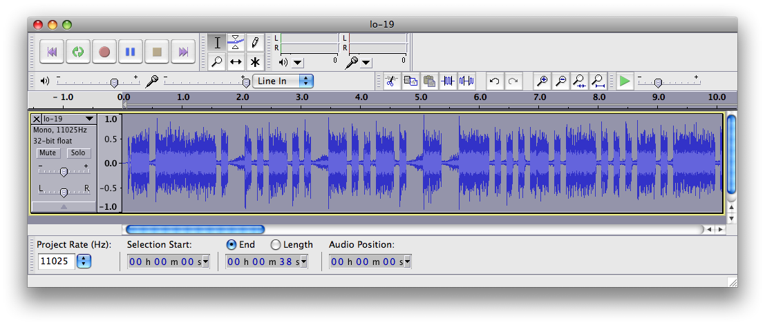
Yep, another AO-51 pass this morning. I frankly was in a rush, and for the life of me can’t remember who it was I worked (although I got my first contact in Nebraska), but luckily, I recorded the QSO as always. When I get a coffee break, I’ll work my way through it. Until then, enjoy the recording.

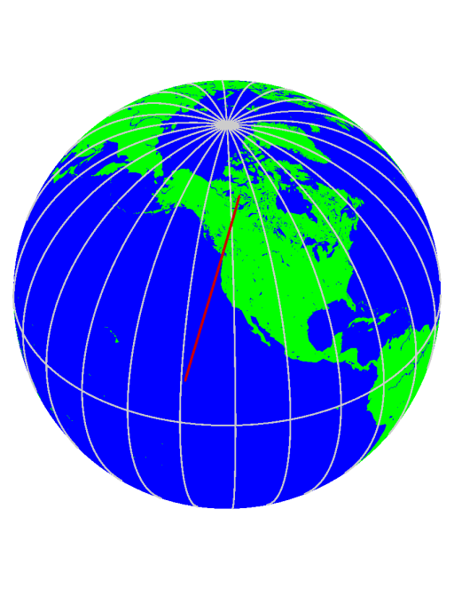
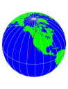
Oh, and my progress on writing satellite tracking software seems to continue. I remembered that long ago I wrote a program for drawing the globe, so I decided to write a short script that would plot the groundtrack of the satellite. If you click on the icon to the left, you can see the north to south pass of AO-51 as it passed over my locale.

AO-51, Jan 16, 2008 16:25Z

Addendum: Got Gene WD0EQP DN91, North Platte Nebraska, AA4Q working mobile into a vertical from DM43, Tempe, AZ. Heard W0DXZ, but he didn’t come back. Too bad, he was in grid EN41, which would have been a pretty reasonable qso. Also got K6CA DM12 in San Diego who was also operating hand held with an Arrow. Oh, and Larry WA6DIR, a satellite regular.

Better version, with the footprint circles in place…
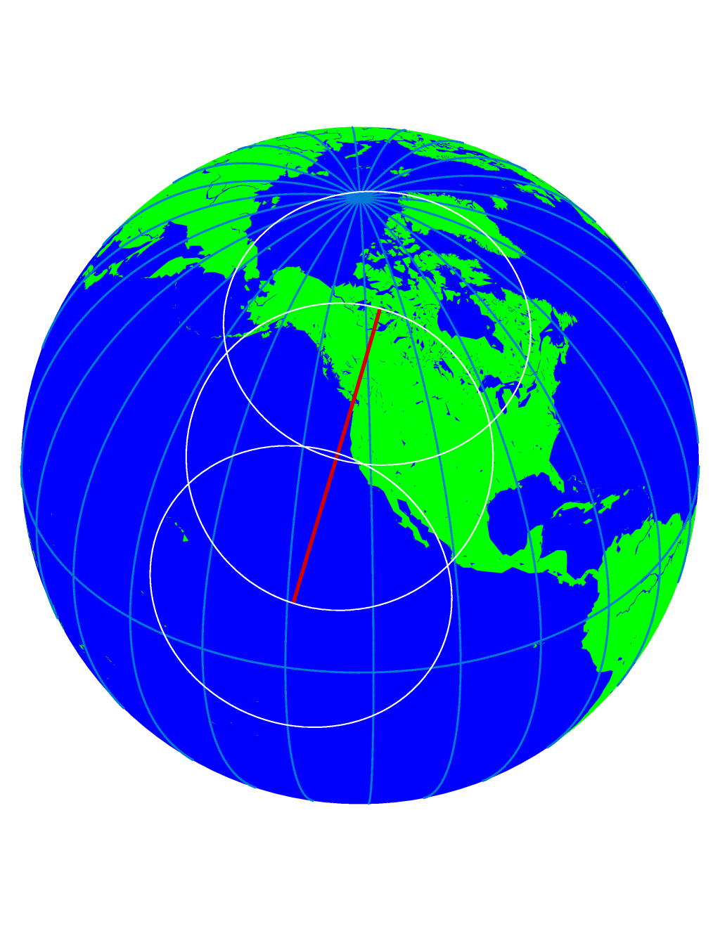
Addendum2: I computed the footprint circle diameter and plotted that at AOS, max elevation and LOS for the satellite. As you can see, toward the end of the pass, Hawaii would have been workable. I can’t get the satellite all the way to the north because of the significant hill behind my house, otherwise I would have been able to work most of Canada, and all of Alaska.

This also points out something that I could do with my new scripts: figure out when a particular satellite is visible from to two different gridsquares. That way, you could figure out routinely whether Hawaii would be possible (for instance). I’ll try to code something like that soon.

An Almost-No-Solder Electronic Organ

This is perhaps too simplistic a project to please the electronic and experimental music lovers among my readers, but it was written by Mark Spencer, WA8SME, a really nice guy whom I’ve chatted with numerous times on the various amateur satellites. He’s got a real interest in teaching electronics and radio to kids, and so he developed this project to allow them to create a simple musical instrument with only minimal amounts of soldering. Neat!

ARRLWeb: An Almost-No-Solder Electronic Organ

Nice NOAA-17 pass today!

Jan 13, 2008, NOAA-17I got a pretty good recording of the NOAA17 pass today, and converted it with my software. Turned out very nice. You can see Catalina and San Clemente Island off the coast of California. One of my better ones to date.

Addendum: I didn’t use my Radio Shack scanner for this, I used my little Yaesu VX-3R instead. I’m beginning to suspect it is a good deal more sensitive than the scanner, although it’s really hard to tell.

Plan 13, in Python

Well, I’ve made some headway on a project that I thought would be cool to write: porting G3RUH’s Plan 13 Satellite Prediction algorithm to a more palateable language than BASIC. I chose python, and it appears to be mostly working. It reads in the TLE orbital elements (same ones I use in “predict” or “gpredict”) and then allows you to create a bunch of satellite objects, and query their positions over time.

Here’s a screendump of a simple test program that I was running this morning:

Monitoring Satellites Using Python Plan13

Satellites which are above the horizon are marked in bold. They are sorted by elevation. The datafields displayed are elevation, azimuth, latitude and longitude of the subsatellite point, velocity, the Doppler velocity, and the frequency of a signal Doppler shifted from 435.845Mhz (just a value I did to check, since I was using PolySat CP3 at the time, which has APRS telemetry downlinked on that frequency). The code requires some additional cleanup, and once I have it all ready to go and documented, I’ll make it available. I think it will have a lot of uses.